The exposed peninsula walk across the bare red cliffs at Madeira's eastern tip, with the Atlantic on both sides. Trail, conditions and what to bring.
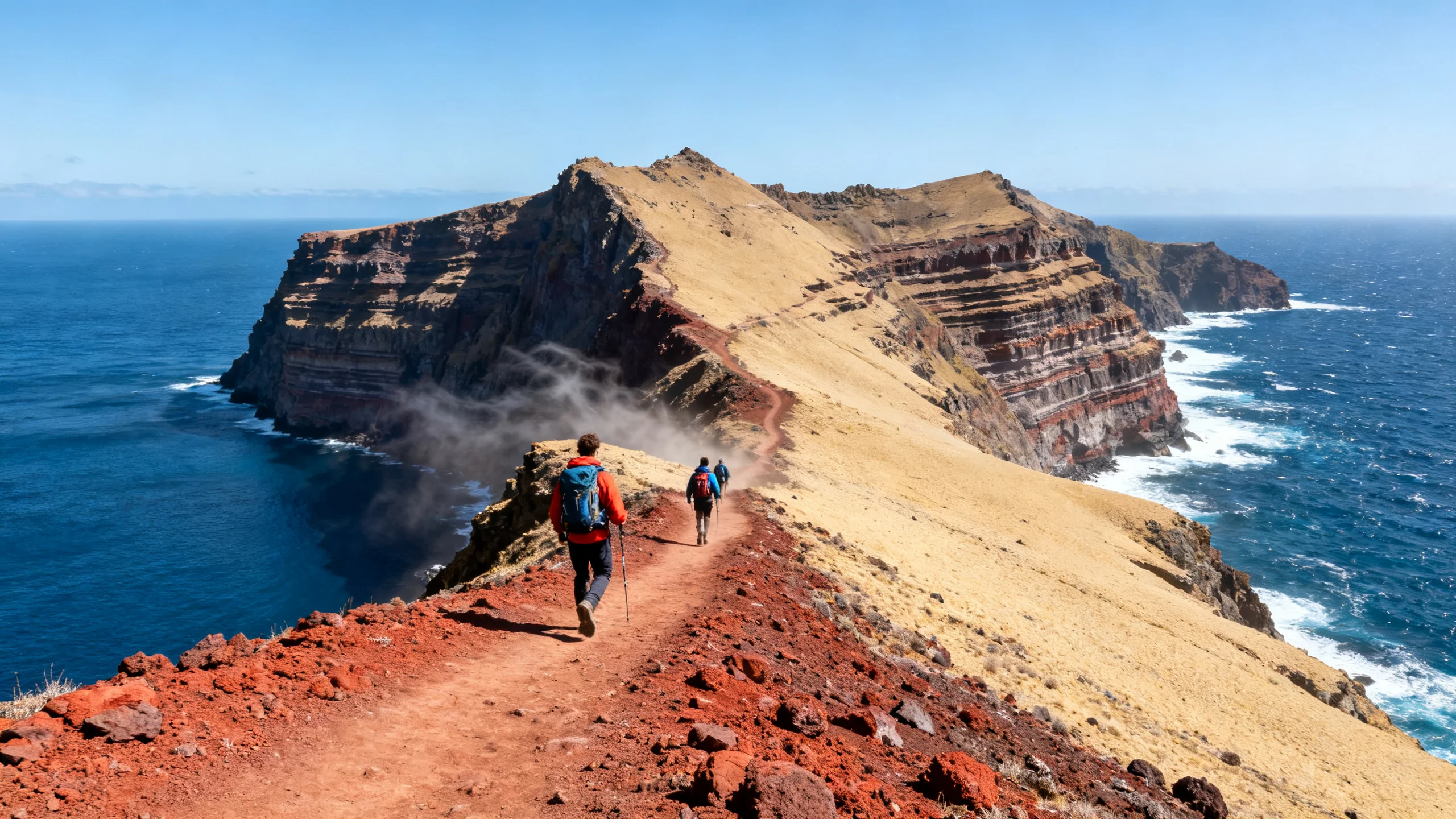
The Ponta de São Lourenço is the thin, treeless peninsula that forms the eastern tip of Madeira, and walking its spine is the most distinctive hike on the island. There are no levadas and no laurel forest here. With no high ground to trap the cloud, the land is bare and wind-scoured, coloured in reds, ochres and rust, and the trail runs along it with the open Atlantic on both sides.
This guide covers the route, what the exposed terrain is like, the conditions that make or break the walk, and how to plan it around the heat and the wind.
The walk, in brief
| Item | Detail |
|---|---|
| Start | Baía d’Abra car park, at the end of the road past Caniçal |
| Length | About 8 km return, out and back along the peninsula |
| Time | Around 3 hours, longer with stops at the viewpoints |
| Difficulty | Moderate: rolling ups and downs, plus a steep climb near the end |
| Trail marking | Signed PR8, the Vereda da Ponta de São Lourenço |
| Conditions | No shade, persistent wind, exposed cliff edges |
What the walk is like
From the Baía d’Abra car park the trail sets off across open ground, with sea cliffs falling away on both sides almost from the start. It is not a flat walk: it rises and dips over a series of small ridges and saddles, and the surface is stony and uneven.
Most of the route runs to a low point near the Casa do Sardinha, a house and garden sheltered among the only real greenery on the peninsula. From there a steeper climb leads up to a final viewpoint over the Ponta do Furado, where the land breaks into islets and the offshore Ilhas Desertas sit on the horizon. Walkers turn around here and return the same way.
Conditions to watch
Two things govern whether this is a good walk on a given day.
The wind. The Ponta de São Lourenço is one of the windiest places on Madeira, and the trail runs close to cliff edges. On a normal breezy day it is fine and bracing. On a genuinely stormy day, with no shelter and exposed ground, it is best skipped.
The heat. With no shade and a fair amount of up and down, the walk is much harder in the summer middle of the day than the distance suggests. Early morning is the answer.
The trail itself is well-marked and needs no navigation skill, but the surface is stony, so proper footwear matters and trainers with grip are the minimum.
Getting to the trailhead
The Baía d’Abra car park sits at the very end of the road, beyond Caniçal in eastern Madeira. From Funchal it is around 40 minutes by the south-coast expressway, and the airport is closer still, which makes this a popular walk for an arrival or departure day.
The car park is small and fills quickly in season, so an early start helps with parking as well as the heat. Without a car, the walk can be done as a guided departure with transfer included, or by combining a taxi out with a pre-booked pickup.
Frequently asked questions
How hard is the Ponta de São Lourenço walk?
Moderate. The trail is well-marked with no technical sections, but it rolls up and down over stony ground and finishes with a steeper climb to the viewpoint. The real difficulty is the exposure: no shade, steady wind, and full sun. In cool weather it is an easy half-day; in summer heat it is more demanding.
Is it safe with children?
Older children who are used to walking manage it well in cool weather. The concern is the cliff edges combined with the wind, so children need to be kept close on the exposed sections. Avoid the walk with young children on a very windy day.
Can I swim at the end of the walk?
There is a small sea-access point near the Casa do Sardinha, but the water here is open and often choppy, so it is not a reliable swim. For a proper swim after the walk, head back toward Caniçal, where Prainha is one of the island’s few natural sand beaches.
How long does the hike take?
Around three hours for the full out-and-back at a steady pace, plus whatever time you spend at the viewpoints. Allowing closer to four hours, with an early start, makes for an unhurried morning and leaves the afternoon free.